Print version
On Sunday 15 September, North Sydney will host the start line of the TCS Sydney Marathon. This event is the sole remaining participant legacy of the Sydney 2000 Olympic Games. The event is owned by Athletics Australia and managed by Pont3.
Event Times
- The TCS Sydney Marathon (Elite Wheelchair Race) will start between 5:50am – 5:52am in North Sydney and finish at the Sydney Opera House Forecourt.
- The TCS Sydney Marathon will start between 6:00am – 6:50am in North Sydney and finish at the Sydney Opera House Forecourt.
- The TCS Sydney Marathon 10km will start between7:20am – 7:40am in Milsons North Sydney and finish at the Conservatorium of Music, Royal Botanic Gardens.
- The TCS Sydney Mini Marathon 4.2km will start between 8:05am – 8:25am in North Sydney and finish at the Conservatorium of Music, Royal Botanic Gardens.
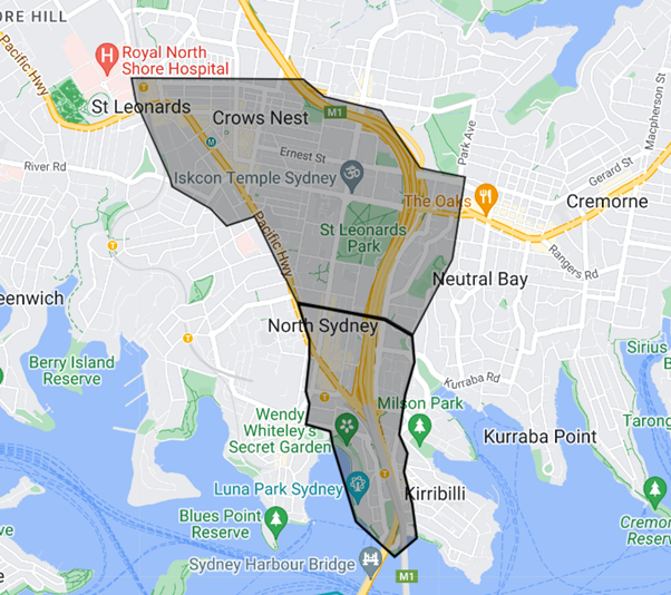
Sydney Marathon - North Sydney - Major Road Closures & Special Event Clearways brochure (PDF 936KB)
For more information about the event please visit the official website: https://sydneymarathon.com/
Road closures
Key roads in North Sydney will be closed between 3.30am and 9.30am (Miller St start line area closed between Falcon St and McLaren St until 12pm).
The Harbour Bridge, Cahill Expressway and Western Distributor will close from 4am to 10am on Sunday morning. Motorists who need to travel southbound are advised to use the Harbour Tunnel and avoid the CBD. Delays are expected so allow extra travel time.
Major roads from the city to Moore Park will be closed until 2pm including College St, Park St, Oxford St and Flinders St. Sections of Macquarie St will remain closed until 3pm while Anzac Pde from Moore Park to Kingsford will be closed from 5am to 11.30am this year.
The Cross City Tunnel will be toll free for the duration of the road closures from 5am – 3pm on Sunday 15 September.
Due to road closures, including the closure of the Sydney Harbour Bridge participants and residents are advised to plan their travel arrangements in advance.
For detailed transport information and to plan your trip, visit transportnsw.info. For real-time traffic updates including closure maps visit livetraffic.com
- Transport for NSW event page: transportnsw.info/sydney-marathon
- Live Traffic NSW: www.livetraffic.com/incident-details/205372
Road closure and clearway maps:
- Sydney Marathon 2024 - Sydney Marathon2024 RoadClosure and ClearwayMap
- Sydney Marathon 2024 - Traffic detour map (PDF 13.3MB)
- North Sydney local access map (PDF 1.1MB)
- St Leonards local access map (PDF 1.1MB)
Resident notification letters
A detailed Public Communications and Notification strategy is currently being undertaken by the event organisers, Pont3, to ensure as many people as possible are made aware about direct and indirect impacts on local and state road systems, so people are able to plan their trips in advance of the day.
A Residential Letterbox Drop and Direct Business Mail-out will be undertaken commencing from Monday 26 August.
Questions and feedback
For event inquiries or feedback in relation to the event itself, please visit the official website sydneymarathon.com/faq/ or email info@sydneymarathon.com
To give feedback on the event to Council on how it has affected you or your business please complete this form: www.northsydney.nsw.gov.au/xfp/form/159 or call (02) 9936 8100
If you are affected by an emergency during the event times please dial 000 or your local police station.
Pre-event Work Zones
Work Zone 1:
Miller Street between Ridge Street and McLaren Street
Friday 8am – Friday 5pm
8 parking spots removed on West side of Miller. 11 spots removed on East side of Miller.
Work Zone 2:
Miller Street between Falcon St and Ridge Street
Saturday 7am – Saturday 2pm
Lane 1 closures in both directions. No parking on either side of the street. Expect delays, avoid if possible.
Work Zone 3:
Ridge Street between Ridge Street and Miller
Saturday 7am to Saturday 2pm
Rolling lane closure and parking disruption. Advise resident and The Greens access only.
Work Zone 4:
Ridge Street between James Place and Miller Street
Saturday 9am to Sunday 12pm
Road closure. Managed access for residents and business owners
Road Closures
Road closures affect both directions unless stated otherwise. Transport for NSW (TfNSW) and NSW Police will progressively re-open roads, after all infrastructure is removed and the roads are cleaned appropriately.
7am Saturday 14 September, 7am to Sunday 15 September, 12pm
Ridge St* between Elliot St and James Place
Sunday 15 September, 3.30am to 8.30am
Walker St* between Ridge and Berry St from
Sunday 15 September, 3.30am to 9.30am
Angelo St* between McLaren St and Berry St
Berry St between Pacific Hwy and Walker St
Bullivant Ln From Berry St
Carlow St* between Miller St and West St
Cassins Ave* From Cassins Ln
Cassins Ln* From Carlow St
Church Ln* between West St and McLaren St
Church St between West St and McLaren St
Church St/Church St Cul De Sac between these Streets. St Thomas Anglican Church Parking
Cunningham St between Ridge St and Kelrose Ln
Denison St between Mount St and Berry St
Elliot St From Ridge St
Faith Bandler Pl From McLaren St
Hampden St From Walker St
Harnett St From McLaren St
Hill St From Walker St
James Pl From Ridge St
Junction Ln From Little Walker St
Kelrose Ln From McLaren St
Little Spring St between Spring St and Berry St
Little Walker St From Pacific Hwy
McLaren St between Pacific Hwy and Walker St
Miller St between McLaren St and Pacific Hwy
Mount St between Walker St and Denison St
Ridge Ln and Kelrose Ln
Ridge St between West St and James Pl
Ridge St between Elliot St and Walker St
Spring St between Denison St and Walker St
Tucker St From Carlow St
Walker St between Mount St and Pacific Hwy
Walker St between Berry St and Mount St Southbound
Ward St From Berry St
Sunday 15 September, 4am to 9.30am
Arthur St between Middlemiss St and Pacific Hwy
Blue St between Miller St and Pacific Hwy
Gas Ln From Miller St
High St between Arthur St and Pacific Hwy (Cahill Exp – On-Ramp) Northbound
Pacific Hwy between High St and William St Northbound
Pacific Hwy* between Bay Rd and High St Southbound
Miller St between Blue St and Pacific Hwy Northbound
Sunday 15 September, 3.30am to 12pm
Miller St between Falcon St and McLaren St
Notes: Local access arrangements
*Ridge St will be closed between James Place and Elliot St from 7am Saturday 14 September till 12 midday Sunday 15 September. Maintained access for resident properties only via Walker St and West St.
*Resident access into Angelo St will be via traffic control and access from McLaren St. There will be no access to Berry St during road closure times.
*Carlow Street resident access will be maintained via West St
*Church Lane Residents managed access out via Church St
*Walker St residents will have displaced parking at Ward St Carpark with access prior to 4am and after 8:30am there will be no exit or entry allowed between 4am and 8:30am.
*Local access to North Sydney area including Wollstonecraft will be via Bay Rd from Pacific Hwy between 4am till 10am. No access to the Sydney Harbour Bridge. CBD access via Falcon St and Sydney Harbour Tunnel during closures.
*Kirribilli residents’ alternate access via Ben Boyd or Wycombe Rd during the road closure times.
Special Event Clearways
Special event clearways are strict no-parking zones for all vehicle types and apply even to local resident parking permit holders and TfNSW Mobility Scheme Permit holders.
Check signs carefully as vehicles left in clearways will be towed and a fee applies. If your vehicle is towed, you can search your vehicle registration at the Find My Car website to find its new location, or alternatively call 132 701 to speak to an operator.
Sunday 15 September, midnight to 10am
- Arthur St between Pacific Hwy and Berry St Western side
- Berry St between Pacific Hwy and Warringah Freeway ramps
- Blue St between Miller St and Pacific Hwy
- Carlow St between Tucker St and Miller St
- Denison St between Berry St and Mount St
- Elliot St From Ridge St
- Falcon St between Pacific Hwy and Warringah Freeway
- High St between Alfred St North and Pacific Hwy
- Little Walker St between Pacific Hwy and Junction Ln
- Little Spring St between Berry St and Spring St
- McLaren St between Pacific Hwy and Walker St
- Miller St between Blue St and Falcon St
- Mount St between Arthur St to Walker St
- Ridge St between James Pl and Warringah Fwy
- Pacific Hwy between Bay Rd and High St Eastern Side
- Pacific Hwy between Reserve Rd and Alexander St Eastern side
- Walker St between Pacific Hwy and Ridge St
Public Transport
Victoria Cross and Crows Nest Metro Stations, plus North Sydney Train Station are within easy walking distance to the event start area and remain open in both directions for participant and non-participant use. Event participants will receive an email with the best station for access to their start wave. The Miller St North Victoria Cross station exit will be for accessible entry/exit only.
Most buses from the northern suburbs will be starting and ending trips at Crows Nest Metro Station. There will be no buses running on Miller St or Pacific Highway south of Crows Nest during the event times while roads are closed for the event. Other bus routes to and from the city and surrounding areas along the course will also be affected.
Bus customers are urged to plan their trips ahead of time as buses may not run to or from stops you usually catch them from, and you may need to transfer to other transport modes to complete your trip.
At the conclusion of the event, event patrons can use the Circular Quay Transport Hub, which is a short walk from the finish areas at the Sydney Opera House Forecourt and the Conservatorium of Music.
Plan your trip here: transportnsw.info/trip
For detailed transport information and to plan your trip, visit transportnsw.info/sydney-marathon
For real-time traffic updates visit Live Traffic NSW: www.livetraffic.com/incident-details/205372